


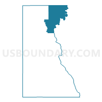
ARMENIA - T 1 Voting District, Juneau County, Wisconsin
About
Outline

Summary
| Unique Area Identifier | 694254 |
| Name | ARMENIA - T 1 Voting District |
| County | Juneau County |
| State | Wisconsin |
| Area (square miles) | 77.72 |
| Land Area (square miles) | 66.02 |
| Water Area (square miles) | 11.69 |
| % of Land Area | 84.95 |
| % of Water Area | 15.05 |
| Latitude of the Internal Point | 44.17861500 |
| Longtitude of the Internal Point | -90.01098370 |
Maps

Graphs
Select a template below for downloading or customizing gragh for ARMENIA - T 1 Voting District, Juneau County, Wisconsin


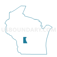
Neighbors
Neighoring Voting District (by Name) Neighboring Voting District on the Map
- FINLEY - T 1 Voting District, Juneau County, WI
- MONROE - T 1 Voting District, Adams County, WI
- NECEDAH - T 2 Voting District, Juneau County, WI
- PORT EDWARDS - T 1 Voting District, Wood County, WI
- PORT EDWARDS - T 3 Voting District, Wood County, WI
- ROME - T 5 Voting District, Adams County, WI
- SARATOGA - T 2 Voting District, Wood County, WI
- STRONGS PRAIRIE - T 2 Voting District, Adams County, WI
Top 10 Neighboring County Subdivision (by Population) Neighboring County Subdivision on the Map
- Saratoga town, Wood County, WI (5,142)
- Rome town, Adams County, WI (2,720)
- Necedah town, Juneau County, WI (2,327)
- Port Edwards town, Wood County, WI (1,427)
- Strongs Prairie town, Adams County, WI (1,150)
- Armenia town, Juneau County, WI (699)
- Monroe town, Adams County, WI (398)
- Finley town, Juneau County, WI (97)
Top 10 Neighboring Unified School District (by Population) Neighboring Unified School District on the Map
- Adams-Friendship Area School District, WI (14,638)
- Nekoosa School District, WI (9,138)
- Necedah Area School District, WI (4,612)
- Pittsville School District, WI (3,863)
Top 10 Neighboring State Legislative District Lower Chamber (by Population) Neighboring State Legislative District Lower Chamber on the Map
- Assembly District 50, WI (59,182)
- Assembly District 72, WI (55,757)
- Assembly District 70, WI (53,911)
Top 10 Neighboring State Legislative District Upper Chamber (by Population) Neighboring State Legislative District Upper Chamber on the Map
Top 10 Neighboring 111th Congressional District (by Population) Neighboring 111th Congressional District on the Map
- Congressional District 3, WI (729,957)
- Congressional District 6, WI (705,102)
- Congressional District 7, WI (689,279)
Top 10 Neighboring Census Tract (by Population) Neighboring Census Tract on the Map
- Census Tract 116, Wood County, WI (5,148)
- Census Tract 109, Wood County, WI (4,088)
- Census Tract 9501, Adams County, WI (2,973)
- Census Tract 1001, Juneau County, WI (2,874)
- Census Tract 9502.02, Adams County, WI (2,674)
Top 10 Neighboring 5-Digit ZIP Code Tabulation Area (by Population) Neighboring 5-Digit ZIP Code Tabulation Area on the Map
- 54494, WI (27,126)
- 54457, WI (8,539)
- 54495, WI (7,637)
- 54646, WI (3,899)
- 54613, WI (1,826)
- 54413, WI (191)